Monday, 24 October 2011
Coastwalk
North Woolwich → Rainham, Essex
 Distance: 11.7 miles
Ascent: 98 metres
Duration: 3 hours 21 minutes
Industrial
« Island Gardens | Tilbury »
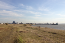
The photograph above is from the largest stretch of greenery I crossed today: Barking Riverside. If you want to see it yourself, you'll have to hurry: this area's about to be redeveloped into new flats and shops too. Beyond the heathland you can make out Ford's plant at Dagenham. That's much more representative of today's walk: industry.

Almost all plots of land I've passed today have either been heavy industry, or wasteland. The thing they've all had in common is two to three metre high fences and signs warning of loose guard dogs. It's not been a particularly pleasant walk.
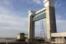
There was one other green space I found, and it's well worth the detour. Just off a corner of River Road in Barking is the Creekmouth Open Space. The path to it is squeezed between industrial units, but drawn on by the towering Barking Barrier (part of the Thames flood defences), I found a small oasis of tranquility peppered with wild flowers and grasses.
Further on the observant map-reader will spot a difficulty at Horse Shoe Corner: a three hundred metre gap between two key rights of way, one of which then proceeds to pass through a warehouse. These paths are indeed impassable, but there is a better solution to keeping to the coast.
Turn off River Road where it bears north to become Renwick Road. Follow the tarmac drive down to the Dagenham Riverside Marketing Suite (a surprisingly pleasant jumble of converted containers) at the river's edge. Now head east along the heathland which will no doubt soon be ripped up as the area's development continues.
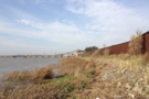 After a kilometre or so, a steel flood wall appears on the right, just before the heathland ends at a fence. Stay on the river side of this wall (there's a concrete path). Your aim is to continue on the shoreline until the other side of the first jetty. This involves scrambling across the outlet of a storm culvert which was dry today, but is clearly anticipated to carry a lot of water at times.
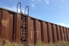 Between the first and second jetties, Thunderer Road runs parallel to the shore. The only remaining obstacle is that huge sea wall. Luckily there are ladders that can be used to climb over it. Take care; on some of the ladders the rungs had come loose from the uprights.
Once on Thunderer Road, find Hindmarsh Road which heads north to join up with the non-existent footpath just to the east of the building it appears to have passed through.
From Dagenham to Rainham there was no alternative but to walk along the road. I stopped outside the Ford "stamping" plant awhile listening to the rhythmic chiming of machines pressing into hot metal. Who says we don't make anything in this country any more?