Saturday, 9 April 2011
Capital Ring
Woolwich → Falconwood
 Distance: 5.7 miles
Ascent: 130 metres
Duration: 1 hour 51 minutes
East-southeast
« Not walked | Not walked »
At Christmas we walked the Jubilee Walkway, a path that approximately follows London's innermost ring-road ("The Ring"). The Capital Ring is another path that circles London, this time roughly following the route of the South and North Circular Roads. Those roads meet at the Woolwich foot tunnel, the starting point of today's walk. The tunnel itself is closed for repairs at the moment. Hopefully it'll reopen on schedule this summer, ready to carry us the final half mile of the route.
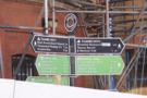
The first thing to note is how superbly the path is signposted. Although it's three quarters of a mile from Woolwich Arsenal station to the start of the walk, the signposts directing pedestrians to the route begin on the railway station platform. This was also the case for the leg from the route to Falconwood station where we finished. It's wonderful to be on a walk with such integrated public transport.
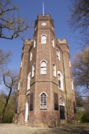 Between the start and end was a chain of parks and public spaces: riversides, formal gardens, woodland and recreation areas hosted by old follies and country houses. The highlight came just after the bizarrely named Severndroog Castle. A few paces further a distant view south from the summit of Shooter's Hill suddenly opened up showing the North Downs on the horizon.
If today's walk is representative of the rest of the Capital Ring we're about to find out just how much greenery really does enclose the city.