Sunday, 27 February 2011
Coastwalk , Isle of Anglesey Coastal Path
Bangor → Beaumaris
 Distance: 8.21 miles
Ascent: 202 metres
Duration: 3 hours 30 minutes
The mother of Wales
« Llanfairfechan | Benllech »
Over ten years ago, I rowed from Caernarfon to Beaumaris as one of a team of four in a Celtic longboat. Starting in the shadow of Caernafon castle, the course took us through The Swellies — a region of notoriously choppy and unpredictable water between the Britannia and Menai bridges — and on to Beaumaris. I don't remember very much about Beaumaris itself so it was a real pleasure walking over the bridge today, re-tracing part of the route inland.
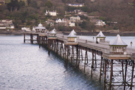 The start of the walk took us past Bangor pier, with its polished domes and wrought ironwork. From the Anglesey side yesterday, the pier almost looked long enough to reach right across the Straits.
To take a break from the road-walking we took a footpath to the southern shore of the Straits through the grounds of Bangor University. The map suggested the route would remain on the shore here but in practise it was half a mile of clambering over slippery rocks and seaweed before eventually rejoining a footpath leading back up to the road.
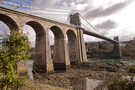
Down on the foreshore we got our first sight of Telford's Menai Suspension Bridge. Walking across it felt like floating across the river; birds flew beneath us as we stood to look out at the view. The significance of the bridge is noted by the fact that the village of Porthaethwy which sits beneath it on the Anglesey side is now known as Menai Bridge.
 After Porthaethwy, the coastal path took us inland to avoid the fast, winding, and pedestrian-hostile A545, favouring instead a higher route via Llandegfan and the muddy fields of Pen-y-parc before dropping us onto the edge of Beaumaris. Along the way we saw our first spring lambs, some of which were only a few days old.