Wednesday, 27 October 2010
Coastwalk , South West Coast Path
Falmouth → Place
 Distance: 3.75 miles
Ascent: 1 metre
Duration: 34 minutes
Across the estuary
« Helford Passage | Portscatho »
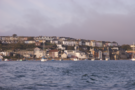
The start of today's walk required crossing two major rivers by boat. The ferries across the Fal and Percuil rivers are sufficiently long that including them in the usual walk write-up would give a distorted picture of the actual distance travelled. This entry then just represents the ferries, plus about a quarter of a mile of walking in Falmouth.
Ferries for St Mawes leave from two different locations in Falmouth. We chose to depart from the Custom House Quay - partly because it was the nearest to our starting point, and partly because a ferry was scheduled to leave within a few minutes of us passing by.
There is another reason to visit this quay. Just behind the Custom House itself is "the King's Pipe": a furnace and chimney used for destroying contraband tobacco. It's not a particularly photogenic structure, but certainly interesting to see.
In St Mawes the ferry across the Percuil (the "Place Ferry") departed close to the point where the boat from Falmouth dropped us. Unlike the St Mawes ferry the Place ferry is seasonal, and even then may be cancelled at short notice due to adverse weather conditions. Indeed it didn't run yesterday due to high winds. The King Harry's Cornwall website provides a handy page which lists all local ferries and their up-to-the-minute running status.
Crossing the rivers provided a great start to the day, with clear views of Falmouth Docks, the huge Carrick Roads estuary (including what looked like a drilling rig) and St Mawes and Pendennis castles.