Friday, 14 September 2007
Coastwalk , South West Coast Path
Tintagel → Port Gaverne
![[Tintagel Island]](../../images/2007/09/cornwall/tintagel-island-thumb-133x99.jpg)
Distance: 8.76 miles
Ascent: 740 metres
Duration: 4 hours 22 minutes
« Crackington Haven | Polzeath »
Tintagel isn't at all what I expected. I knew of the island castle and its association with the great Arthurian legend so although I was hoping for a rock topped with towering ruins. What you get to see from the mainland though is really just an island, and if you know just where to look you can make out some ruined walls.
![[Young Adder]](../../images/2007/09/cornwall/baby-adder-thumb-134x100.jpg)
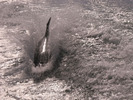
The path south of Tintagel didn't disappoint though. Just as we started to descend to Trebarwith Strand I stopped dead in my tracks. Something had zipped across the path behind Emma's footsteps. Closer investigation revealed an Adder - the first time I've ever seen Britain's only venomous snake in the wild.
The South West Coast Path Association grade the next stretch as "severe", and our guide-book joined in advising of "seven steep valleys" to cross and pessimistically warning the stretch could take five hours. After yesterday's walk I was a little nervous, but when it came down to it the time flew by. We had the path to ourselves and loved every step of it, with natural features and discarded industrial scars providing plenty to look at.
Thursday, 13 September 2007
Coastwalk , South West Coast Path
Port Gaverne → Polzeath
![[Port Quin]](../../images/2007/09/cornwall/port-quin-thumb-134x100.jpg)
Distance: 10.1 miles
Ascent: 747 metres
Duration: 5 hours 36 minutes
For the second half of our week away we've moved to the north coast of Cornwall. Despite our late booking we've found a room in a National Trust house overlooking Port Quin. The house (centre-left of the photo) is at the halfway point of today's walk so we walked to Polzeath first, then caught the bus to Port Gaverne before walking back to Port Quin.
The outward part of the walk was easy: a quick tramp along relatively gently undulating clifftops. After a diversion by the Rumps headland which gave our room its name, the highlight was reaching Pentire Point which provides a spectacular view across Padstow Bay and the mouth of the Camel. From here Polzeath (and the bus to Port Gaverne) was a short walk downhill and across the beach.
Port Gaverne is just north of Port Isaac. We chose to start the inbound leg here because parking (for the next walk to the north) looked as if it would be easier here than in Port Isaac. The route between the two villages is along the road. Port Isaac itself is another classic Cornish village: narrow streets, tea rooms and shops full of chintz.
On the map, the walk from Port Isaac to Port Quin looked easier than from Port Quin to Polzeath. On the ground it's a very different story. The section between Varley Head and Kellan Head is a killer: a constant rollercoaster with no easy exit.
That said, being able to step directly off the coast path into our accommodation was bliss. This is definitely a walk I'd recommend to folk staying at Doyden House.
Tuesday, 11 September 2007
Personal
The ferry's friend
After yesterday's walk we felt there was more to see in Mevagissey so headed back to spend the day there today. Besides, it meant we'd get to ride on the ferry twice more. What we'd not expected was that the ferry ride home would by far be the biggest highlight of the day.
As the ferry came alongside the harbour wall, it brought a friend with it: a lone dolphin.
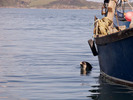
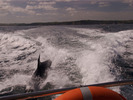
The dolphin follwed us the whole way back to Fowey (ten miles or so), jumping in and out of the boat's wake. Once in Fowey it switched allegiances to the Polruan ferry, accompanying it back and forth across the Fowey estuary a few more times.
I am now throughly ashamed of last year's photographs of specs on the horizon. (Was that really a year ago?) To make up, there are a few more photos from today on flickr.
Update, 19 September:
Was it Findol?
Monday, 10 September 2007
![[Morwenna as an angel]](../../images/2007/09/cornwall/morwenna-angel-thumb.jpg)
Coastwalk , South West Coast Path
Mevagissey → Par
![[Buggies outside the Ship Inn, Pentewan]](../../images/2007/09/cornwall/pentewan-ship-thumb.jpg)
Distance: 12.4 miles
Ascent: 811 metres
Duration: 5 hours 52 minutes
View from the ferry
« Portloe | Fowey »
The ideal lunch-spot is somewhere deserted. It's up high, with a good view of where you've come from and where you're going to. A place to linger and breathe slowly. If you're walking from Mevagissey to Par, that spot is Black Head - a small promontory fort separated from the mainland by a narrow isthmus.
We saw the headland from the ferry that took us to the start of the walk this morning and as we ate the ferry passed again on its return trip to Fowey.
![[Morwenna carving]](../../images/2007/09/cornwall/morwenna-thumb.jpg)
About half a mile further west we saw a beautifully isolated house. The path approached the grounds beside a recently felled tree whose stump had been carved to form the image of "Morwenna".
I'd certainly recommend this walk to anyone. Better still - if you're up for a longer distance - tack on the Par to Fowey leg. Start the day at Mevagissey and review the walk from the sea on the way home on the Fowey to Mevagissey ferry.
Saturday, 1 September 2007
Coastwalk , South West Coast Path
Swanage → Sandbanks
![[Southern end of the Southwest Coast Path]](../../images/2007/09/dorset/swcp-thumb.jpg)
Distance: 7.93 miles
Ascent: 212 metres
Duration: 3 hours 24 minutes
The end
« Chapman's Pool | Christchurch »
The South West Coast Path is 630 miles long and it ends here.
Unlike most long-distance walkers reaching the Poole Ferry we're not in a position to celebrate. At 193 miles we've walked just one quarter of the National Trail but for the first time I realised we'd definitely complete the whole thing one day.
The high cliffs of Old Harry Rocks and the long sandy beach at Studland represent the path in miniature. Today's walk would make a good final chapter.
![[Emma atop Handfast Point]](../../images/2007/09/dorset/clifftop-thumb.jpg)
But our eyes are set beyond the south-west. The length of the entire British coast is harder to track down. Most measurements put it between six and seven thousand miles and by coincidence I've walked about a quarter of that too. I'm less sure about whether I'll ever complete it.
Still, there's no point leaving a job undone. There's plenty more rock and sand to see yet.